EuroSAT



Overview
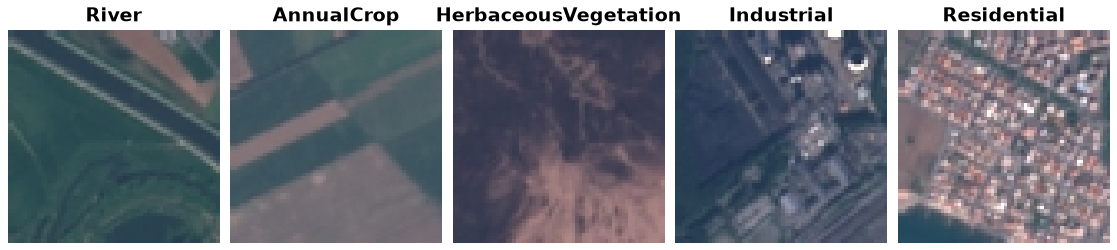
EuroSAT is a land use / land cover classification dataset built from Sentinel-2 satellite imagery, covering 10 classes with 27,000 labeled 64x64 RGB images in total.
Train: all 27,000 images (no official split ships with the archive)
There is no official train/val/test split, so this builder exposes the
full dataset as a single train split (the same handling used for
AWA2). Hold out your own validation set if you need one.
Data Structure
When accessing an example using ds[i], you will receive a dictionary
with the following keys:
Key |
Type |
Description |
|---|---|---|
|
|
RGB image, 64x64 |
|
int |
Land use / land cover class (0-9) |
Classes
AnnualCrop, Forest, HerbaceousVegetation, Highway, Industrial, Pasture, PermanentCrop, Residential, River, SeaLake
Usage Example
from stable_datasets.images.eurosat import EuroSAT

ds = EuroSAT(split="train")

sample = ds[0]
print(sample.keys())  # {"image", "label"}

class_names = ds.info.features["label"].names
print(class_names[sample["label"]])

# Optional: make it PyTorch-friendly
ds_torch = ds.with_format("torch")
References
Official website: https://github.com/phelber/EuroSAT
License: MIT License (Sentinel-2 imagery is also subject to the Copernicus Sentinel Data Terms and Conditions)
Paper: EuroSAT: A Novel Dataset and Deep Learning Benchmark for Land Use and Land Cover Classification (IEEE JSTARS 2019)
Citation
@article{helber2019eurosat,
  title={EuroSAT: A Novel Dataset and Deep Learning Benchmark for Land Use and Land Cover Classification},
  author={Helber, Patrick and Bischke, Benjamin and Dengel, Andreas and Borth, Damian},
  journal={IEEE Journal of Selected Topics in Applied Earth Observations and Remote Sensing},
  year={2019}
}